Circuit de la Croix-Rouge
Saint-Gildas-des-Bois
Destination
Circuit de la Croix-Rouge
44530
ST GILDAS DES BOIS
GPS coordinates
Latitude : 47.51700
Longitude : -2.03732
Itinerary Info
- Type of Excursion :
- Items/Points of Interest :
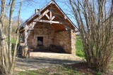
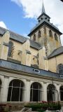
- Heritage
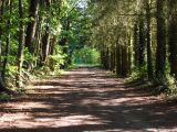
- Bocage and countryside
- Period :
- Less than 2 hours
- Practical information :
- Town of departure Saint-Gildas-des-Bois
- Length in km 8 km
- Average duration 2h00
Download
General information
- Useful Information :
- Ideal time to practice toute l'année
- (Geographical) Location from Point of Departure :
- Distance from the railway station 500 m (St-Gildas-des-Bois)
- Distance from the shops sur place
- Distance from a bus stop 150 m - LILA - T5 - Arrêt : Pré Burel
Accessibility
- Disabled Access :
- Not accessible for people with reduced mobility