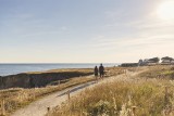
La CĂ´te Sauvage
Le Pouliguen
FICHE_INFO_SIMPLE_LIBELLE_DESTINATION
La CĂ´te Sauvage
Office de Tourisme du Pouliguen
Port Sterwitz - BP 53
44510
LE POULIGUEN
GPS coordinates
Latitude : 47.28058
Longitude : -2.42802
Itinerary Info
- Type of Excursion :
- Items/Points of Interest :
- Heritage
- Coastline
- Period :
- An Half-day
- Itinerary details :
- Departure Le Pouliguen
- Arrival Le Pouliguen
- Practical information :
- Town of departure Le Pouliguen
- Length in km 9.5 km
- Average duration 2h30
Download
- PDF_Topoguide RANDO_Fiche n°24_La Côte Sauvage_Le Pouliguen (939.63 Ko)
- Trace GPX_La cĂ´te sauvage_Le Pouliguen (75.67 Ko)
- Trace GPX_La côte sauvage_Variante marée haute_Le Pouliguen (66.07 Ko)
- PDF_Hiking Topoguide Beautifull escape_File n24_The Wild Coast (4.41 Mo)
- PDF_Wander-Topoführer Schöne Wanderausfluge_Datei Nr24_Die Côte Sauvage (4.56 Mo)
General information
- Useful Information :
- Section subject to the tides on the circuit/route section soumise aux marées à la Pointe de Penchâteau

- Ideal time to practice Printemps et été
- (Geographical) Location from Point of Departure :
- Distance from the railway station 750 m (Le Pouliguen)
- Distance from a bus stop 750 m - LILA - 6 - ArrĂŞt : Gare SNCF
Accessibility
- Disabled Access :
- Not accessible for people with reduced mobility