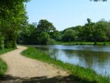
Sentier du Canal
Guenrouet
Destination
Sentier du Canal
Quai Saint Clair
44530
GUENROUET
GPS coordinates
Latitude : 47.52288
Longitude : -1.95234
Itinerary Info
- Type of Excursion :
- Items/Points of Interest :
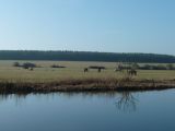
- Bocage and countryside
- Channels, Rivers and estuaries
- Period :
- An Half-day
- Practical information :
- Town of departure Guenrouet
- Length in km 12 km
- Average duration 3 h
Download
- PDF_Topoguide RANDO_Fiche n°2_Sentier du Canal_Guenrouët (530.9 Ko)
- Trace GPX_Sentier du Canal_Guenrouët (14.77 Ko)
- PDF_Fiche_Circuit du Canal (1.02 Mo)
- PDF_Wander-Topoführer Schöne Wanderausfluge_Datei Nr2_Kanalpfad_Sentier du canal (5.49 Mo)
- PDF_Hiking Topoguide Beautifull escape_File n2_Canal Trail (Sentier du Canal) (5.52 Mo)
General information
- Useful Information :

- Ideal time to practice toute l'année
- (Geographical) Location from Point of Departure :
- Distance from the railway station 5 km - St-Gildas-des-Bois
- Distance from the shops 500 m - Guenrouët
- Distance from a bus stop 1.3 km - LILA - T5 - Arrêt : Mairie
- Distance from a place to swim sur place - piscine
Accessibility
- Disabled Access :
- Not accessible for people with reduced mobility